Paul Smith, "An eyot [island] in the River Camel between Polbrock and Pendavey looking upstream" captioned as "The Camel valley in winter," http://en.wikipedia.org/wiki/River_Camel
"Estuaries are bodies of water and their surrounding coastal habitats typically found where rivers meet the sea. Estuaries harbor unique plant and animal communities because their waters are brackish—a mixture of fresh water draining from the land and salty seawater.
"Estuaries are some of the most productive ecosystems in the world. Many animal species rely on estuaries for food and as places to nest and breed. Humans communities also rely on estuaries for food, recreation, and jobs."
National Oceanic and Atmospheric Administration, http://oceanservice.noaa.gov/education/tutorial_estuaries/welcome.html
The following text is directly copied from: http://en.wikipedia.org/wiki/River_Camel
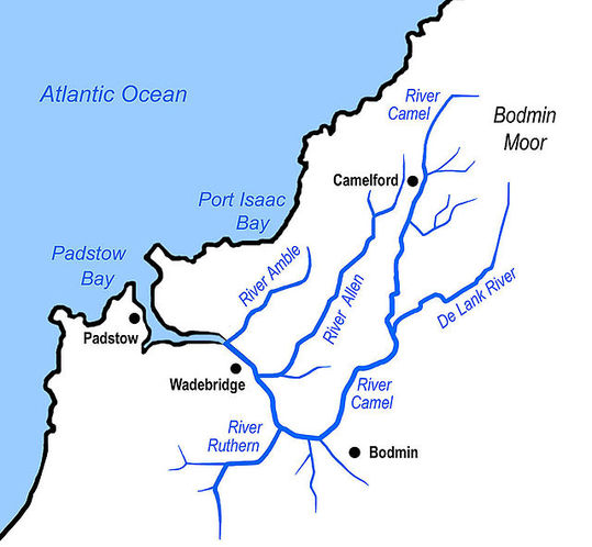
"The River Camel (Cornish: Dowr Kammel, meaning crooked river) is a river in Cornwall, England, UK. It rises on the edge of Bodmin Moor and with its tributaries drains much of North Cornwall. The river flows into the eastern Celtic Sea between Stepper Point and Pentire Point having covered about 30 miles. The river is tidal upstream to Egloshayle and is popular for sailing, birdwatching and fishing. The name Camel comes from the Cornish language for 'the crooked one,' a reference to its winding course. Historically the river was divided into three named stretches. Heyl (Cornish: Heyl, meaning estuary) was the name for the estuary up to Egloshayle, the River Allen (Cornish: Dowr Alen, meaning shining river) was the stretch between Egloshayle and Trecarne, whilst the Camel was reserved for the stretch of river between its source and Trecarne.
"Estuaries are bodies of water and their surrounding coastal habitats typically found where rivers meet the sea. Estuaries harbor unique plant and animal communities because their waters are brackish—a mixture of fresh water draining from the land and salty seawater.
"Estuaries are some of the most productive ecosystems in the world. Many animal species rely on estuaries for food and as places to nest and breed. Humans communities also rely on estuaries for food, recreation, and jobs."
National Oceanic and Atmospheric Administration, http://oceanservice.noaa.gov/education/tutorial_estuaries/welcome.html
The following text is directly copied from: http://en.wikipedia.org/wiki/River_Camel
"The River Camel (Cornish: Dowr Kammel, meaning crooked river) is a river in Cornwall, England, UK. It rises on the edge of Bodmin Moor and with its tributaries drains much of North Cornwall. The river flows into the eastern Celtic Sea between Stepper Point and Pentire Point having covered about 30 miles. The river is tidal upstream to Egloshayle and is popular for sailing, birdwatching and fishing. The name Camel comes from the Cornish language for 'the crooked one,' a reference to its winding course. Historically the river was divided into three named stretches. Heyl (Cornish: Heyl, meaning estuary) was the name for the estuary up to Egloshayle, the River Allen (Cornish: Dowr Alen, meaning shining river) was the stretch between Egloshayle and Trecarne, whilst the Camel was reserved for the stretch of river between its source and Trecarne.
|
Image on left, Andy F, "A sketch map of the River Camel, Cornwall UK, and its tributaries."
"The next five and a half miles beside the broadening Camel to Padstow is the most beautiful train journey I know." John Betjeman, "Betjeman's Cornwall" http://en.wikipedia.org/wiki/River_Camel |
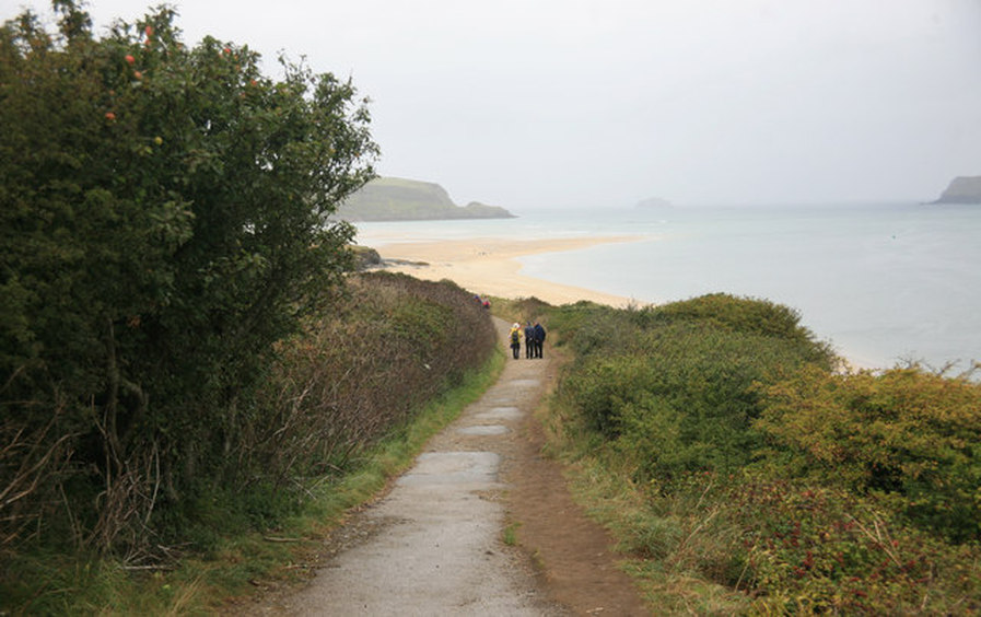
Roger Geach, "Along the Camel Estuary on a wet day." "Even on a wet day the view is great. The mouth of the Camel as seen from the coast path." © roger geach and licensed for reuse under this Creative Commons License. Taken at: Padstow Beach, South West England, http://www.thebeachguide.co.uk/photos/padstow-2596048.htm
|
"The Camel Estuary (Cornish: Heyl Kammel) stretches from Wadebridge downstream to the open sea at Padstow Bay. The quays at Wadebridge are now developed with apartments and retail space on the west bank. North of the quays, the river passes under a concrete bridge carrying the A39 bypass and past the disused Vitriol Quay. Downstream of Burniere Point the valley widens on the right with acres of salt marsh where the River Amble flows in. Here the Cornwall Birdwatching and Preservation Society has hides on both sides of the river; those on the Camel Trail are open to the public.
"The main river follows the western side of the valley, while on the eastern side a barrage prevents the rising tide from entering the River Amble. "Downstream from the Amble, a test bore into Dinham Hill is only accessible from the foreshore at low tide. Cant Cove lies on the east bank below Cant Hill and the rotting ribs of a ship project from the mud. Almost opposite Cant Hill on the west bank is Camel Quarry, the piles of waste rock clearly visible above the river with the remains of a quay visible at low water. From here the mud gives way to sand and Gentle Jane, named after a legendary lady who treated the ills of all comers. "From Porthilly Cove on the east bank, the estuary widens and swings to the north. On the west bank, the Camel Trail crosses the triple-span “Iron Bridge” over Little Petherick Creek then passes below Dennis Hill and its obelisk. "The fishing port of Padstow stands on the west bank from where the Black Tor Ferry (officially owned by the Duchy of Cornwall) carries people across the river to Rock. |
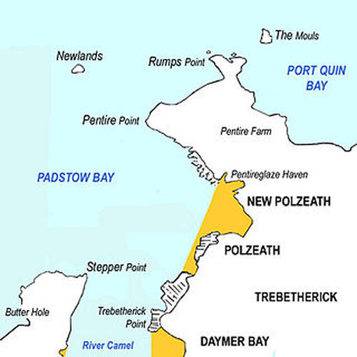
Andy F, "Sketch map of the River Camel estuary,"
http://en.wikipedia.org/wiki/River_Camel 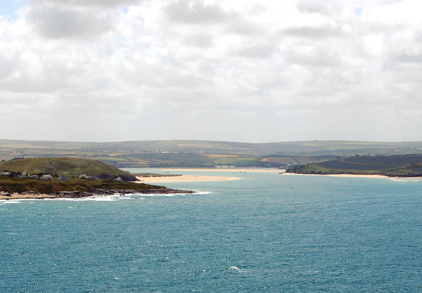
Andy F, "The estuary of the River Camel seen from Pentire Point with Trebetherick Point in the foreground." http://en.wikipedia.org/wiki/River_Camel
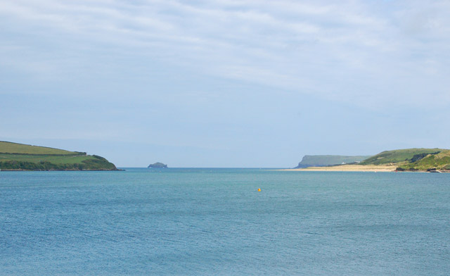
Andy F, "The estuary of the River Camel looking seaward from Padstow." http://en.wikipedia.org/wiki/River_Camel
Andy F, "The Doom Bar sandbank extends across the Camel estuary."
http://en.wikipedia.org/wiki/River_Camel |
"The mouth of the Camel lies between Stepper Point on the west and Pentire Point on the east, and each headland shelters sandy beaches. On the west side of the estuary, Tregirls beach is protected by Stepper Point. At the northern end of Tregirls beach is Harbour Cove and between here and Hawker's Cove evidence has been found of occupation during the Bronze Age, Iron Age and Roman periods, and use of Harbour Cove for trading vessels.
"In 1827, Padstow Harbour Association chose Hawker's Cove as the location for the Padstow lifeboat. Operations were taken over by the RNLI in 1856. A new lifeboat station and slipway were built in 1931 and a second lifeboat stationed at Hawker's Cove. The station closed in 1962 because silting rendered the channel too shallow. The building is now converted to residential use.
"Beyond Hawkers Cove, the Doom Bar extends across the estuary. The sandbank has been the graveyard of many ships. A legend as to how the Doom Bar came about describes how a local fisherman is reputed to have shot a mermaid with an arrow, with the result that she cursed Padstow by putting the sandbar between the harbour and the sea.
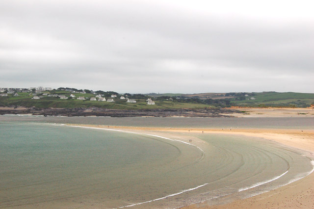
"On the east side of the estuary, the village of Rock is a centre for sailing, dinghy racing and marine leisure. From Rock, dunes and intertidal sands extend north as far as Brea Hill. Beyond Brea Hill is Daymer Bay with a beach north of which is the settlement of Trebetherick. A stretch of rocky foreshore swings east to the bay and beach at Polzeath, a location for surfing. North of Polzeath, Pentire Point marks the northeast extremity of the estuary."
